Down the Cariboo trail
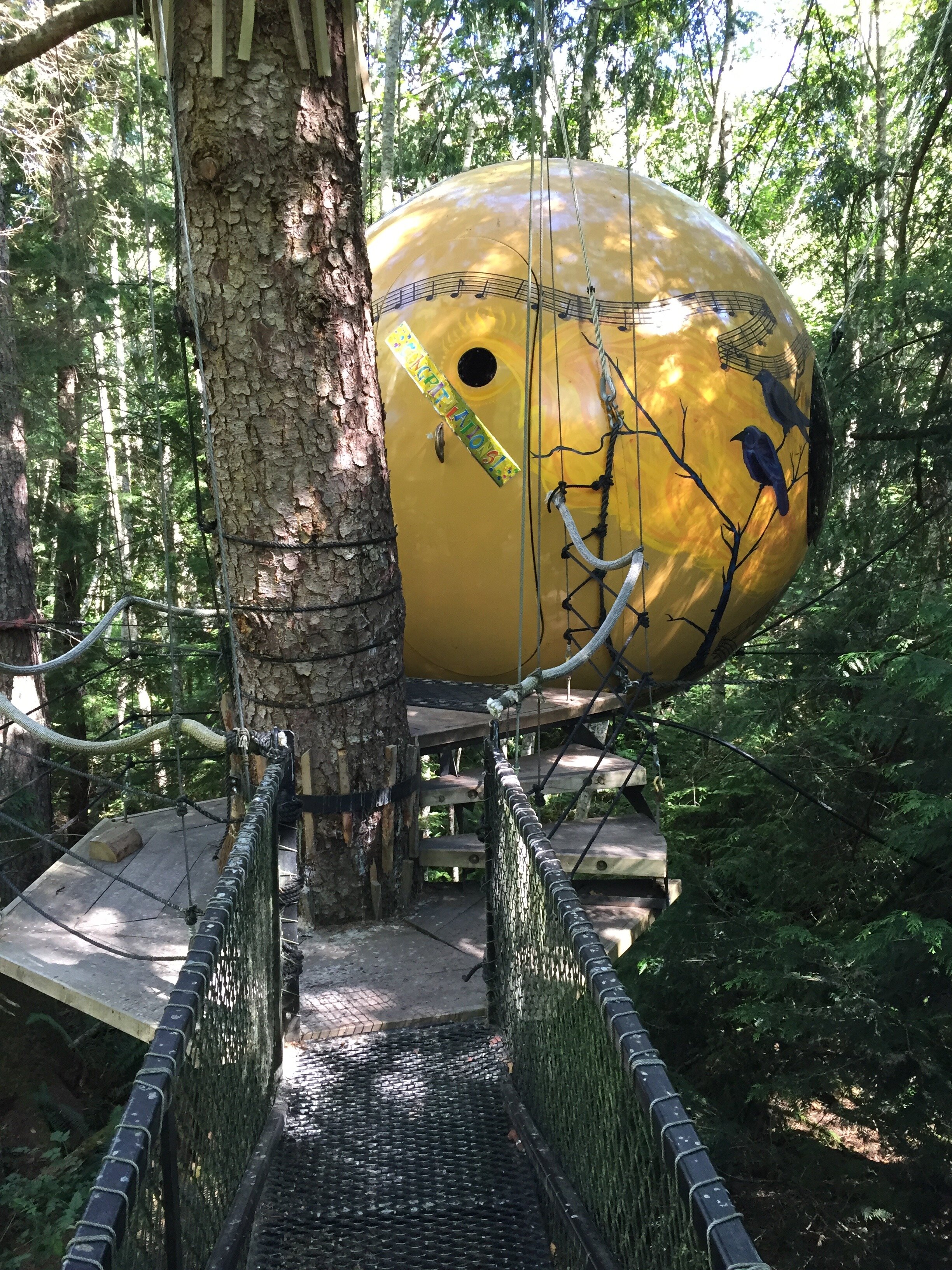 Since I last wrote, one of my articles from my British Columbia trip got published in the Washington Post. It’s about an amazing tree house hotel (Free Spirit Spheres) we stayed in near Qualicum Beach. Veeka took a huge delight in the 9-foot-wide wood sphere that was our room for two days, as it was perched in the tree canopy and reached only by a spiral staircase wrapped around a tree.The last few days of our trip were spent heading south from Prince George, the largest city in northern British Columbia. We headed for Barkerville, a historic town at 4,300 feet altitude in the mountains southwest of Prince George. This was a major city back in the days of the Cariboo Gold Rush, which sprang to life during the years of the American Civil War. Gold was discovered on the Fraser River in 1858 and 30,000 miners – once they heard of this – showed up in New Caledonia, which is what BC was known as at the time. People had to bring everything in on mules or on boats until a stagecoach road was built in 1865. The Cariboo Wagon Road began at Lillooet (in the mountains north of present-day Vancouver) and went some 300 miles to Quesnel.Barkerville is a reconstituted town with a school house, church, stores and many other things – along with costumed actors who play the parts of historic characters from the era – that were built along a gold-laden Williams Creek. There were three bed and breakfasts in town and we stayed at the King B&B, a good choice in that there aren’t a whole lot of lodging choices in the area and Quesnel – the nearest large town – is 50 miles away. We met a lot of nice people there over the next two days, most of them from Vancouver or Toronto and a lot of them were ethnically Chinese. As I learned later,
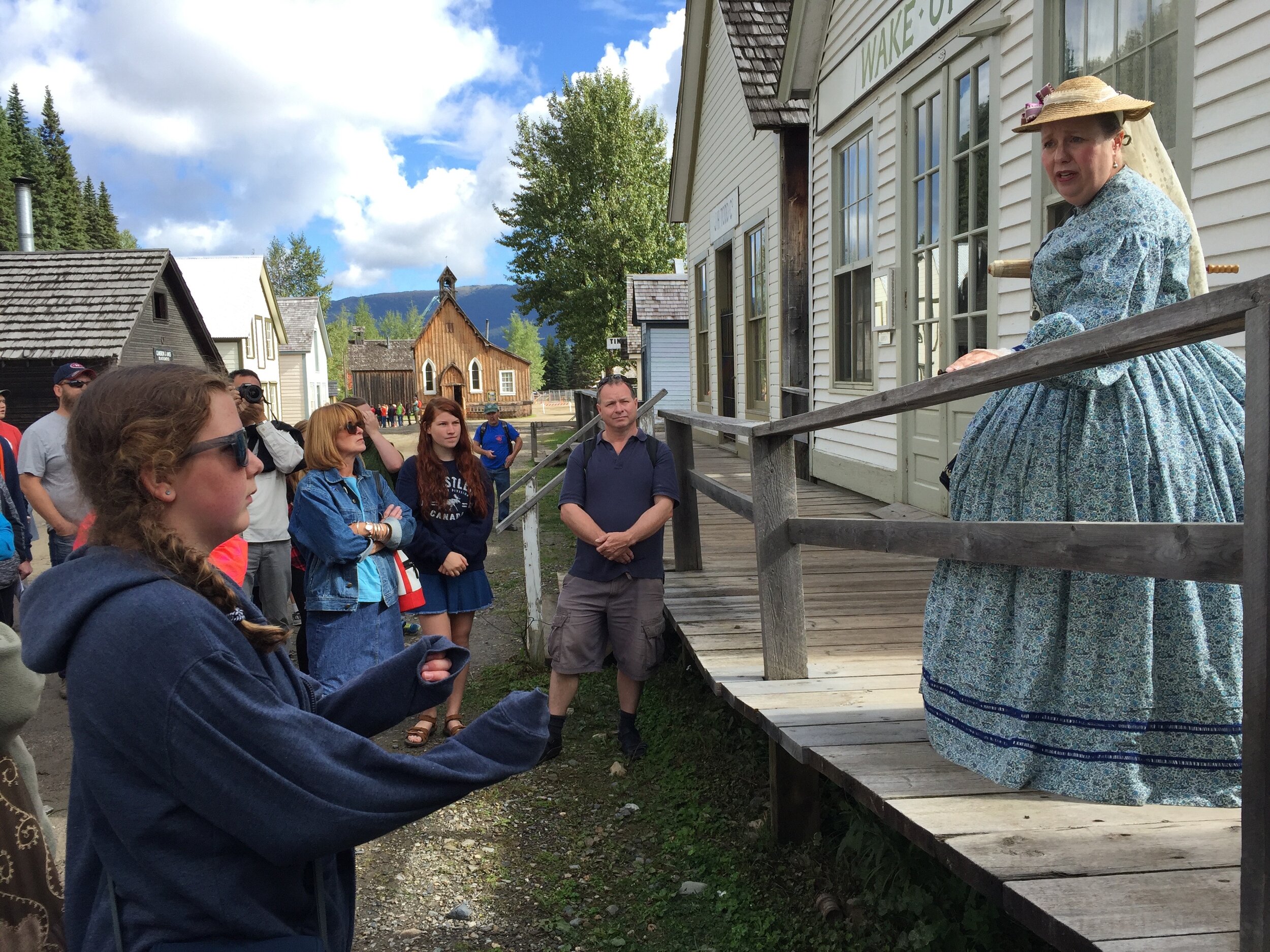 Chinese immigrants played a large part in the mining around Barkerville. Our arrival was a bit rocky, as all of Barkerville, including the visitor center, shuts down at 6 pm and we arrived at 6:30. I eventually located our lodgings, then whisked Veeka off to Wells, a town three miles away where we found a place to eat. One other quirk about the area: there was no cell phone service on iPhones.Barkerville was in a valley surrounded by pine trees. The town had all-dirt streets, very much like Dawson City. We repaired to the visitors center where we got a pamphlet and day’s schedule. We first opted for the general tour of the town, delivered by a “Miss Florence Wilson” who had come there on one of the “bride boats” in 1864. This very entertaining actress wore a blue and white dress with hoop skirt and a straw hat, a black belt with a large silver buckle and a silver locket and carrying a parasol.At the time, Victoria was the major civilized outpost in western Canada. Thegovernor of British Columbia aka new Caledonia, James Douglas, was mixed race (Creole and Scottish) and he married a mixed-race woman who was part Cree. Knowing that, 300 black families moved from California to BC just before the Civil War because they were afraid that even though California was a “free” state, things could change. After the miners came hurdy gurdy girls, dentists, assayers, lawyers, blacksmiths and other professionals to jumpstart a civilization in the middle of the woods.
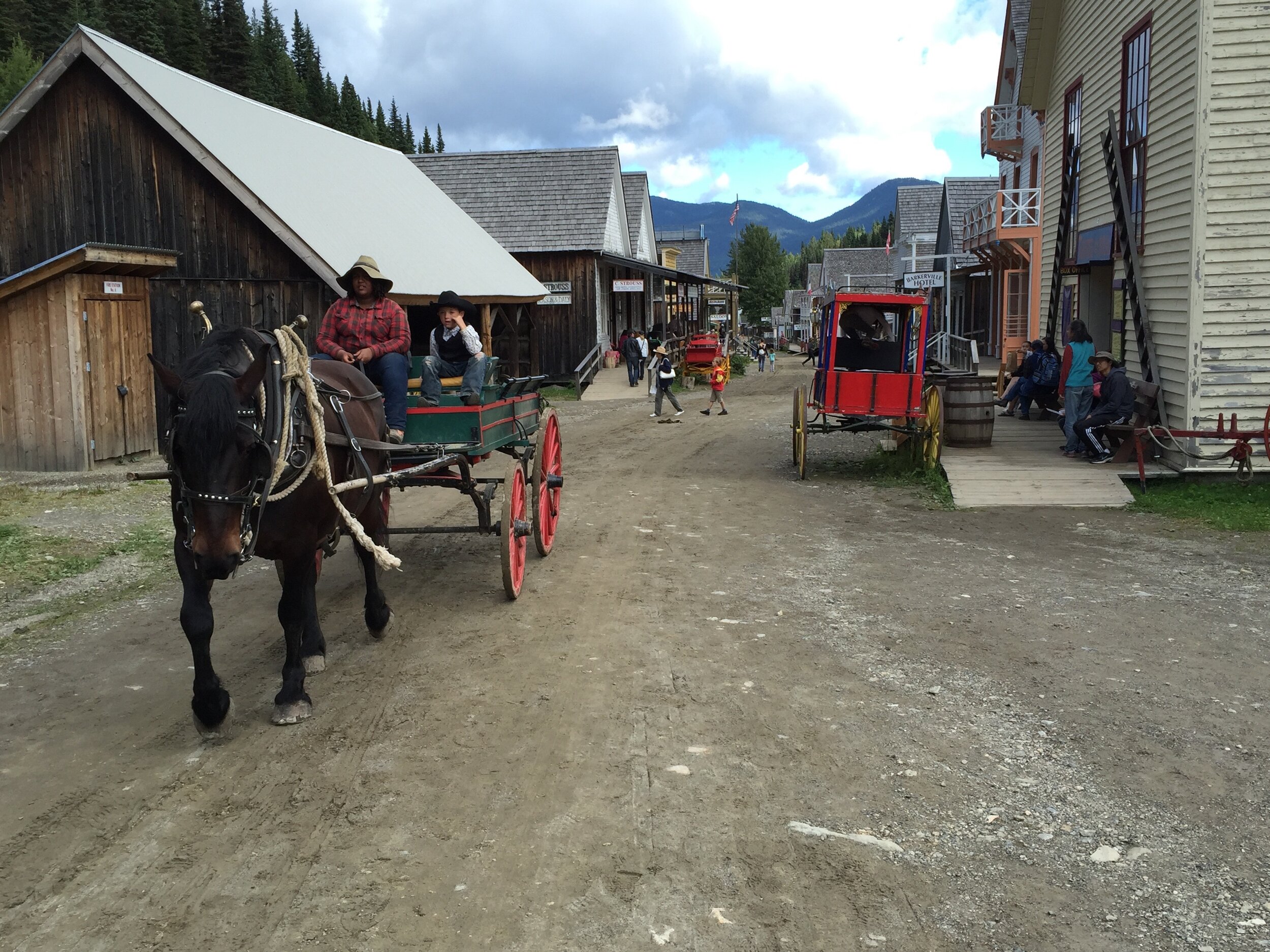 Veeka’s favorite stop was the schoolhouse, where all the females were forced to put on bonnets, examine each others’ hair for lice and address the teacher as “m’am” during a lesson set in 1874. If we so much as whispered to a neighbor, the teacher yelled at us. Then we walked up the hill to an archway made of logs and spruce boughs with “Chinatown” bannered atop it. The tour guide, an archeology prof from Simon Fraser U, explained the reason that mostly Chinese men emigrated was that many of the women had bound feet at the time, which meant they could not walk anywhere, much less hike about central British Columbia.I never thought I’d be interested in the history of Chinese immigration to western Canada, but this was fascinating. It took two months to get a boat from Hong Kong to Victoria and the Chinese were kept in the hold the whole time. From New Westminster to Barkerville, it was a 3-week walk. Still, 5,000-8,000 Chinese lived there and they even built terraced gardens on a nearby hill to remind them of home. Every year, the town’s main street would flood, which would create a sea of mud but also wash away a year’s worth of garbage and horse dung.
 I tried to push off early the next morning, as I had 500 miles to go before reaching Seattle. We had reservations at a place in Pemberton, just north of Whistler, but it was a long drive to get even there.Driving back to the main highway (97), we first stopped in Quesnel to walk across the pedestrian bridge we’d seen two years ago during our trip to Alaska. It’s a lovely 10-minute walk and a must-see if you drive through there. We also dropped by a bookstore to pick up a book on Gold Rush history, then headed south. The next major community, William Lake, was a lovely oasis and about five miles south was a restored 1896 schoolhouse. Children can practice dipping quill pens into inkwells there, which fascinated Veeka. When the school house was opened, it was state of the art, housing 40 students in new double desks, with a cloak room, a barrel stove and separate outhouses for the boys and girls.I had to get to Lillooet, which was Mile 0 on the Cariboo Trail while it was still light so I could take photos. From the junction of Highways 97 and 99, it was about 70 minutes to Lillooet on one of the more terrifying highways I’ve been on. Yes, the views of the Fraser River a zillion feet below were amazing and the mountain ranges were dramatic, but the hairpin turns and steep drops were enough to keep my eyes glued to the road. Plus I nearly ran out of gas. At 6 pm, we pulled into Lillooet, which had a few stores and cafes but seemed run-down to me. A pyramid-shaped Mile 0 marker surrounded by bright colored zinnias and chrysanthemums was flanked by a rock shop and museum proclaiming: “1859 Mile 0 Cariboo Trail. Welcome to Lillooet: BC’s little nugget.”
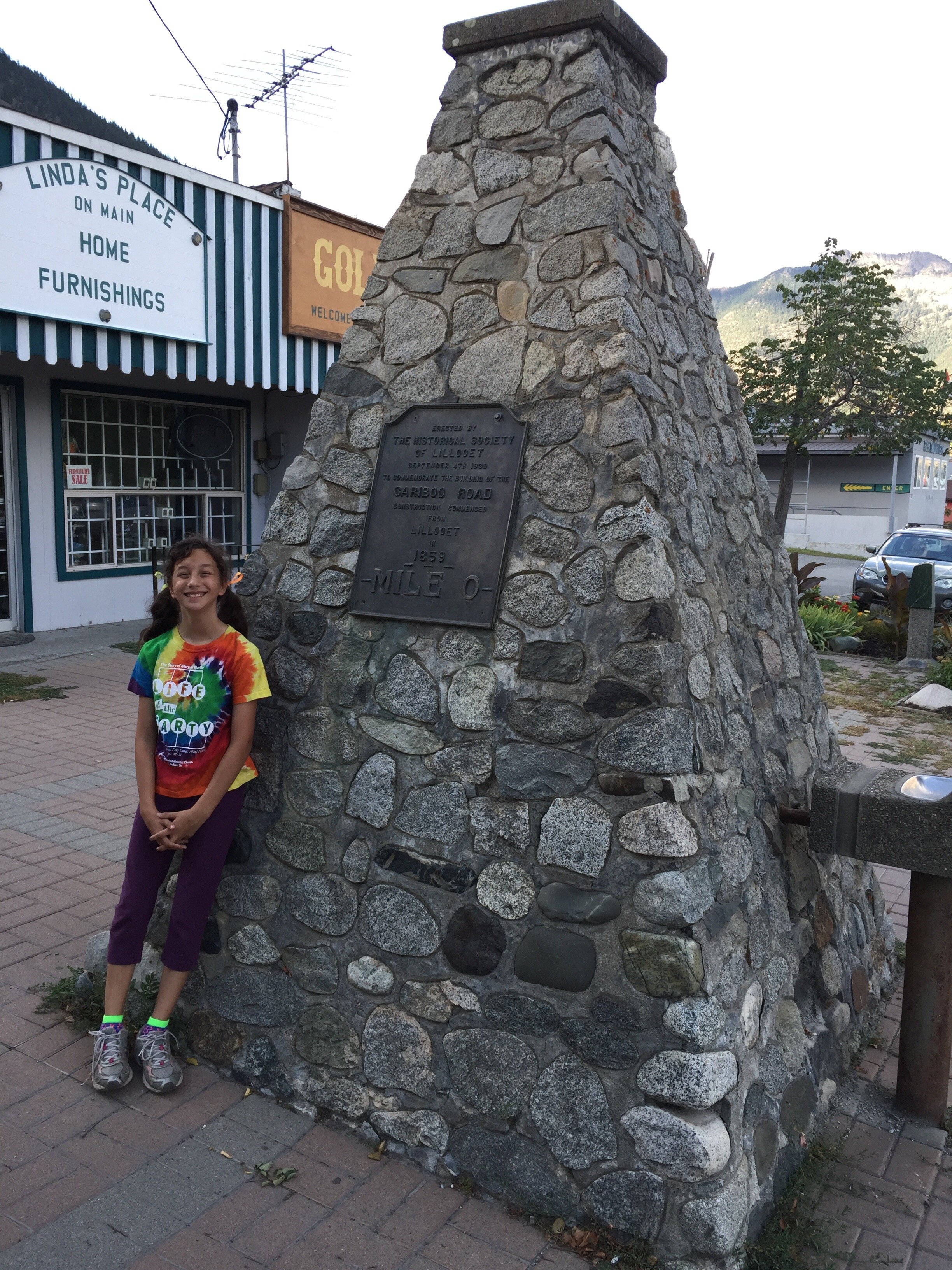 It was another hour through the woods to Pemberton, where we stayed at the Pemberton Valley Lodge, which was the most reasonable accommodation I could find that included a pool for Veeka. There weren’t a ton of restaurants in town, so we found a take-out pizza place.The next day was spent first driving 25 miles to Whistler, where there were so many tourists, one could hardly drive. One had to pay for parking everywhere plus the line at the visitor’s center was long. I got a map of the area, we dropped by a very plush IGA for picnic foods, then headed out to the far side of Alta Lake (took forever to find the turnoff for it) where we found a grassy beach at Rainbow Park and clear, clear water. Veeka later said it was the highlight of her trip and she couldn’t tear herself away from this lovely spot with a gorgeous mountain range staring at us from across the lake. I can see why people like to vacation here in the summer. It was hard to leave this lovely spot but I’d promised a friend we’d meet for dinner at the Hooked Fish Bar, which was in Surrey, near the border. So we drove down to Vancouver and got stuck for nearly 2 hours in deadly traffic. But the seaside restaurant was wonderful and it faced west toward the sunset. Eventually, we had to say good-bye and get back to Seattle. In all, I drove 2,244 miles.Since then, Veeka has started fifth grade and we’ve been squeezing in after-school hikes and swims in local lakes before the weather goes south on us.